
File:EU-United Kingdom.svg

Size of this PNG preview of this SVG file: 713 × 600 pixels. Other resolutions: 285 × 240 pixels | 571 × 480 pixels | 913 × 768 pixels | 1,218 × 1,024 pixels | 2,435 × 2,048 pixels | 2,045 × 1,720 pixels.
Original file (SVG file, nominally 2,045 × 1,720 pixels, file size: 7.32 MB)
Summary
Español:
(Verde) Reino Unido.
(Verde claro) La Unión Europea (UU).
(Gris) Europa.
(Gris claro) La región circundante.
Vea también:
| Description |
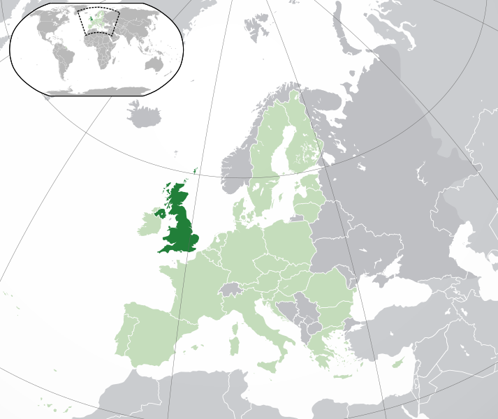
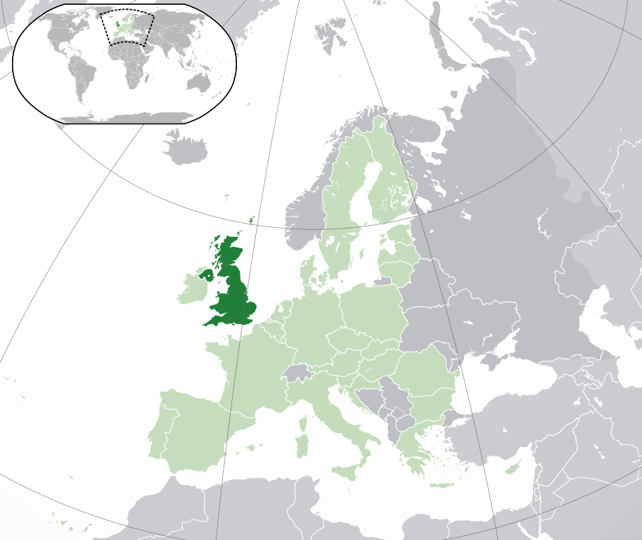
English: (Dark-Green) United Kingdom. (Light-Green) The rest of the European Union (EU). (Dark-gray) The rest of Europe. (Light-gray) The surrounding region.
See also: |
| SVG development | |
| Date | |
| Source | |
| Author | NuclearVacuum |
| Other versions |
Derivative works of this file: Knowledge of German EU map.svg
|
| SVG development |


.svg)

.svg)


Licensing
I, the copyright holder of this work, hereby publish it under the following licenses:
This file is licensed under the Creative Commons Attribution-Share Alike 3.0 Unported license.
- You are free:
- to share – to copy, distribute and transmit the work
- to remix – to adapt the work
- Under the following conditions:
- attribution – You must give appropriate credit, provide a link to the license, and indicate if changes were made. You may do so in any reasonable manner, but not in any way that suggests the licensor endorses you or your use.
- share alike – If you remix, transform, or build upon the material, you must distribute your contributions under the same or compatible license as the original.

|
Permission is granted to copy, distribute and/or modify this document under the terms of the GNU Free Documentation License, Version 1.2 or any later version published by the Free Software Foundation; with no Invariant Sections, no Front-Cover Texts, and no Back-Cover Texts. A copy of the license is included in the section entitled GNU Free Documentation License. |
You may select the license of your choice.
File history
Click on a date/time to view the file as it appeared at that time.
| Date/Time | Thumbnail | Dimensions | User | Comment | |
|---|---|---|---|---|---|
| 04:52, 4 March 2015 |  | 2,045 × 1,720 (7.38 MB) | Leftcry | Reverted to version as of 15:27, 6 August 2014 Messed up visual accuracy | |
| 14:12, 21 February 2015 |  | 2,045 × 1,720 (2.62 MB) | VS6507 | Spain. Greece. Slovakia. Cyprus. Romania VETO | |
| 19:34, 16 November 2014 |  | 2,045 × 1,720 (7.38 MB) | Leftcry | Reverted to version as of 15:27, 6 August 2014 Please go to your talk page | |
| 16:38, 16 November 2014 |  | 2,045 × 1,720 (2.62 MB) | A2D2 | The map must show the original de-jure status with no breakaway regions, as it was originally created. An alternative map showing the de-facto status with breakaway regions needs to be created instead. | |
| 15:43, 16 November 2014 |  | 2,045 × 1,720 (7.26 MB) | A2D2 | Reverted to version as of 17:57, 12 July 2014 | |
| 15:27, 6 August 2014 |  | 2,045 × 1,720 (7.38 MB) | Rob984 | Sudan border | |
| 18:01, 12 July 2014 |  | 2,045 × 1,720 (7.26 MB) | Rob984 | Added Gradient and Longitude and latitude lines. Otherwise it's difficult to tell what kind of projection this is and therefore potentially misleading. | |
| 17:57, 12 July 2014 |  | 2,045 × 1,720 (7.26 MB) | Rob984 | Improved version: More accurate coastline, borders, etc. Slightly different centre point. | |
| 22:23, 30 June 2013 |  | 2,045 × 1,720 (2.62 MB) | AxG | Croatia added as EU member | |
| 15:07, 23 October 2009 |  | 2,045 × 1,720 (2.61 MB) | NuclearVacuum | fixing glitch |
File usage
There are no pages that use this file.
Global file usage
The following other wikis use this file:
- Usage on ami.wikipedia.org
- Usage on bn.wikibooks.org
- Usage on de.wikibooks.org
- Usage on dv.wikipedia.org
- Usage on en.wikipedia.org
- Usage on en.wikibooks.org
- Usage on en.wikiquote.org
- Usage on eu.wikipedia.org
- Usage on fr.wikipedia.org
- Usage on id.wikibooks.org
- Usage on jv.wikipedia.org
- Usage on koi.wikipedia.org
- Usage on ku.wiktionary.org
- Usage on mg.wikipedia.org
- Usage on myv.wikipedia.org
- Usage on nds-nl.wikipedia.org
- Usage on ne.wikipedia.org
- Usage on new.wikipedia.org
- Usage on nl.wikipedia.org
- Usage on pap.wikipedia.org
- Usage on pih.wikipedia.org
- Usage on ru.wikinews.org
- Блэр угрожает судом газете
- Стив Фоссет побил рекорд дальности беспосадочного перелёта
- Великобритания передаёт своего хакера США
- Джимми Картер возлагает ответственность на Тони Блэра
- Чиновники кабинета Блэра уходят в отставку
- Буш опаснее Кима
- Великобритания планирует собственную космическую программу
- Вашингтон предлагал Англии провести военную акцию в Иране
- В Лондоне произошёл крупный пожар
- Обама и Медведев сделали шаг к соглашению о СНВ
- Национальная портретная галерея Великобритании угрожает гражданину США судебным иском за загрузку изображений на сайт Викимедиа
- Рабочие английского завода по производству ветрогенераторов остановили производство
- За последний год ВВП Великобритании упал на 5,6 %
- Британский школьник признан виновным в расовом домогательстве школьницы
- В Великобритании бюджетный дефицит достиг рекордного уровня
- Викиновости:Шаблоны/Инфобоксы/Страны
- Шаблон:Великобритания
- Погиб Джеймс Хесельден, владелец компании Segway
- Нобелевские лауреаты выступили за смягчение британского визового режима для учёных
- Лондон, не умеющий красиво проигрывать
- В Великобритании разрешат продакт-плейсмент
- Между Лондоном и Москвой разразился новый шпионский скандал
- Лондон собирается сделать главу российского МИДа невъездным
- Английские футболисты выступили против антисемитизма
- Великобритания планирует запретить экспорт в США препаратов, используемых для смертной казни путём инъекции
- Принц Уильям и Кэтрин Миддлтон принесли брачные обеты
- Журналисты ВВС протестуют против сокращения штатов
View more global usage of this file.