Search results
Jump to navigation
Jump to search
Search categories • Skip PDFs • View other tools
|
Help
|
|
Browse
|
Search
|
Create the page "Range maps" on this wiki!
 4956 529 10559 3133 Old Man Range 965 991 1533 859 10559 3133 Mt Somers Range 3436 1586 6687 1190 10559 3133 Winterslow Range English author name string:...(10,559 × 3,133 (20.67 MB)) - 11:44, 21 October 2023
 8 °. Range to target site: 284.9 km. Original image scale range: 57.0 cm/pixel (with 2 x 2 binning) so objects ~171 cm across are resolved. Map projected...(2,560 × 1,920 (5.59 MB)) - 07:54, 12 February 2023
 Commons Attribution-Share Alike 4.0 truetrue English Sunrise over Benmore Range, New Zealand Hindi बेनमोरे रेंज पर सूर्योदय, न्यू जीलैंड Wikimedia username:...(11,647 × 2,412 (9.69 MB)) - 10:15, 24 December 2022
 File:Bodie ghost town.jpg (category Pages with maps)English In the State Historic Park, east of the Sierra Nevada mountain range French Dans le parc historique d'État à l'Est des montagnes de la Sierra...(1,024 × 768 (140 KB)) - 12:34, 3 December 2023
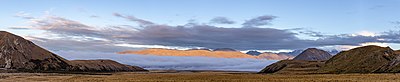 362 16968 3467 Lake Heron English Fog around Lake Heron close to Taylor Range, Canterbury, New Zealand. Bulgarian Мъгла около езеро Херън, окръг Кентърбъри...(16,968 × 3,467 (26.18 MB)) - 15:40, 20 August 2022
 File:View towards Mons Sex Millia from Garnet Peak, New Zealand.jpg (category Poplars Range)(1835 m) English View towards Mons Sex Millia from Garnet Peak. Poplars Range, Canterbury Region, New Zealand author name string: Michal Klajban Wikimedia...(14,455 × 4,428 (54.04 MB)) - 07:16, 4 December 2022
 reproduction, and selling them for profit. Consider these maps as yours." English Mount Everest 3D Map by Tom Patterson with English annotation Czech 3D mapa...(5,000 × 3,750 (4.28 MB)) - 03:09, 16 December 2022
 7001 1568 11968 3181 Torlesse Range 1062 2539 3007 582 11968 3181 Mt Torlesse 6627 926 2050 343 11968 3181 Craigieburn Range English Wikimedia username:...(11,968 × 3,181 (21.03 MB)) - 03:38, 28 January 2024
 File:Asbestnaya Mount, Adygea, Гора Асбестная, виды с вершины, Адыгея, Западный Кавказ.jpg (category Pages with maps)4.0 Creative Commons Attribution 4.0 truetrue English Greater Caucasus Range from Mount Asbestnaya, in fog and clouds, Caucasus Mountains. author name...(4,912 × 3,264 (14.06 MB)) - 04:40, 22 May 2024
 1317 8176 3256 Castle Hill Peak 3822 643 4303 725 8176 3256 Craigieburn Range 2902 2072 3260 1051 8176 3256 Red Peak English author name string: Michal...(8,176 × 3,256 (15.49 MB)) - 11:43, 21 October 2023
 File:Ajaccio phare citadelle.jpg (category Pages with maps)Alike 3.0 truetrue 713 1045 102 204 4288 2412 English: Complementary light (range: 7 miles - 13 Km) Français : Feu en mer complémentaire (portée : 7 miles...(4,288 × 2,052 (5.16 MB)) - 03:52, 27 July 2023
 File:Tilisunahütte Panorama.jpg (category Pages with maps)1768 Kristbergsattel 1483 m English Panoramic picture of Rätikon mountain range in Austria, with Austrian Alpine Club hut Tilisunahütte on the left and...(6,711 × 1,768 (8.68 MB)) - 09:20, 22 January 2024
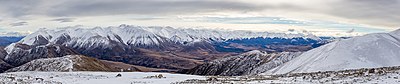 Castle Hill Peak and Foggy Peak 1297 1011 7051 709 14209 2979 Craigieburn Range 8863 1685 480 301 14209 2979 Mt Plenty 1474 975 710 390 14209 2979 Porters...(14,209 × 2,979 (21.89 MB)) - 11:24, 21 October 2023
 File:Зимний Таганай.jpg (category Pages with maps)Attribution-Share Alike 4.0 truetrue English View to Otkliknoj Greben, Taganay range Russian Вид на Откликной гребень с Двуглавой сопки German Blick zum Berg...(6,000 × 4,000 (18.72 MB)) - 22:01, 21 May 2024
 English Misinchinka Ranges seen from a Coastal GasLink Pipeline construction road. determination method: SHA-1...(22,130 × 4,000 (32.57 MB)) - 17:42, 3 May 2024
 File:Segovia - 01.jpg (category Pages with maps)379 3888 1944 Church of St. Andrew 1774 719 2070 248 3888 1944 Guadarrama Range 2435 1040 185 141 3888 1944 Church of St. Millán 2075 1162 243 165 3888...(3,888 × 1,944 (4.54 MB)) - 07:30, 5 September 2023
 File:Badaia - Vistas con niebla -BT- 01.jpg (category Badaia mountain range)3432 4571 Cantabria mountain range 267 801 244 206 3432 4571 Zaldiaran 46 694 3325 427 3432 4571 Vitoria mountain range 1945 794 252 191 3432 4571 Busto...(3,432 × 4,571 (5.41 MB)) - 20:42, 24 October 2023
 Wikipedia. User:Pcb21 after User:Vardion, Sperm Whale range map v.4 See also: Wikipedia:WikiProject Cetaceans#Range maps English determination method: SHA-1...(1,357 × 628 (49 KB)) - 19:53, 19 February 2024
 English Range Map Hawaii...(3,400 × 2,200 (3.04 MB)) - 06:32, 8 December 2023
 2006-04-06T11:15:53Z Pmaas 341x341 (5928 Bytes) Range Map Plains Zebra. Historical range: Red. Present range: Green. Based on maps in "Duncan, P. (ed.). 1992. Zebras...(341 × 341 (8 KB)) - 14:08, 10 November 2021


