File:Larsen iceshelves.png: Difference between revisions
Jump to navigation
Jump to search
Content deleted Content added
uploaded a new version of File:Larsen iceshelves.png: (BOT): Reverting to the most recent version before uploads (originally uploaded on 2005-08-28 14:32 by Riumplus). |
cleanup, {{crop}} |
||
| Line 1: | Line 1: | ||
== {{int:filedesc}} == |
== {{int:filedesc}} == |
||
{{Information |
{{Information |
||
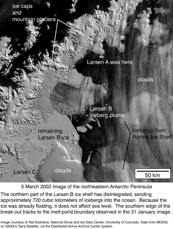
|Description={{en|1=Approximate locations of the missing Larsen A and Larsen B ice-shelves |
|Description={{en|1=Approximate locations of the missing Larsen A and Larsen B ice-shelves. |
||
Note the irregularly shaped island in the north-east corner of the map. Just south of it is where the missing Larsen A ice-shelf began. Note the two islands off the west coast of the peninsula. The southern boundary of the missing portion of Larsen B seems to lie just south of the southernmost island.}} |
|||
{{sv|1=Ungefärligt läge för Larsen A och Larsen B, de delar av Larsenshelfen som försvann 1995 (A) och 2002 (B)}} |
{{sv|1=Ungefärligt läge för Larsen A och Larsen B, de delar av Larsenshelfen som försvann 1995 (A) och 2002 (B)}} |
||
|Source=I created this map using [http://www.aquarius.geomar.de/omc/ this online map creation tool]. Then I coloured the area that I believe is where the Larsen A and Larsen B ice-shelves were. I used [http://web.pdx.edu/~chulbe/science/Larsen/images/LarsB.030502.annot.jpg this satellite photo] from [http://web.pdx.edu/~chulbe/science/Larsen/larsen2002.html this page] for reference. <br/> |
|||
|Source=From English Wikipedia |
|||
Transferred from [http://en.wikipedia.org en.wikipedia] |
|||
|Author=[[w:User:Geo Swan]] |
|||
|Date={{original upload date|2004-11-05}}|Author=[[:en:User:Geo Swan|Geo Swan]] at [http://en.wikipedia.org en.wikipedia]. |
|||
|Date=2004-11-05 |
|||
|Permission= |
|Permission= |
||
|other_versions= |
|other_versions= |
||
}} |
}} |
||
{{crop}} |
|||
| ⚫ | |||
| ⚫ | |||
{{PD-user-en|Geo Swan}} |
|||
== {{Original upload log}} == |
|||
{{ImageUpload|full}} |
|||
The original description page is/was [http://en.wikipedia.org/w/index.php?title=File%3ALarsen_iceshelves.PNG here]. All following user names refer to en.wikipedia. |
|||
* 2005-08-28 14:32 [[:en:User:Riumplus|Riumplus]] 519×774× (14856 bytes) ''Losslessly recompressed the image, shrinking file size by 56%'' |
|||
==See also== |
|||
* 2004-11-05 19:10 [[:en:User:Geo Swan|Geo Swan]] 519×774× (33455 bytes) ''<nowiki>Approximate locations of the missing Larsen A and Larsen B ice-shelves</nowiki>'' |
|||
*[[:File:Ant-pen map.png]] |
|||
| ⚫ | |||
{{PD-Self}} |
|||
| ⚫ | |||
[[Category:Antarctic Peninsula]] |
[[Category:Antarctic Peninsula]] |
||
Revision as of 16:44, 25 May 2011
Captions
Captions
Add a one-line explanation of what this file represents
Summary
| Description |
English: Approximate locations of the missing Larsen A and Larsen B ice-shelves.
Note the irregularly shaped island in the north-east corner of the map. Just south of it is where the missing Larsen A ice-shelf began. Note the two islands off the west coast of the peninsula. The southern boundary of the missing portion of Larsen B seems to lie just south of the southernmost island.
Svenska: Ungefärligt läge för Larsen A och Larsen B, de delar av Larsenshelfen som försvann 1995 (A) och 2002 (B) |
| Date | 5 November 2004 (original upload date) |
| Source |
I created this map using this online map creation tool. Then I coloured the area that I believe is where the Larsen A and Larsen B ice-shelves were. I used this satellite photo from this page for reference. |
| Author | Geo Swan at en.wikipedia. |
Licensing:
Geo Swan at the English-language Wikipedia, the copyright holder of this work, hereby publishes it under the following license:
| This file is licensed under the Creative Commons Attribution-Share Alike 3.0 Unported license. Subject to disclaimers. | ||
| Attribution: Geo Swan at the English-language Wikipedia | ||
| ||
| This licensing tag was added to this file as part of the GFDL licensing update. |

|
Permission is granted to copy, distribute and/or modify this document under the terms of the GNU Free Documentation License, Version 1.2 or any later version published by the Free Software Foundation; with no Invariant Sections, no Front-Cover Texts, and no Back-Cover Texts. A copy of the license is included in the section entitled GNU Free Documentation License. Subject to disclaimers. |
| This work has been released into the public domain by its author, Geo Swan at English Wikipedia. This applies worldwide. In some countries this may not be legally possible; if so: Geo Swan grants anyone the right to use this work for any purpose, without any conditions, unless such conditions are required by law. |
Original upload log
The original description page is/was here. All following user names refer to en.wikipedia.
File history
Click on a date/time to view the file as it appeared at that time.
| Date/Time | Thumbnail | Dimensions | User | Comment | |
|---|---|---|---|---|---|
| current | 03:37, 26 May 2011 |  | 496 × 774 (11 KB) | Ras67 (talk | contribs) | cropped, background removed |
| 16:41, 25 May 2011 |  | 519 × 774 (15 KB) | OgreBot (talk | contribs) | (BOT): Reverting to the most recent version before uploads (originally uploaded on 2005-08-28 14:32 by Riumplus). | |
| 16:41, 25 May 2011 |  | 519 × 774 (33 KB) | OgreBot (talk | contribs) | (BOT): This is the version originally uploaded on 2004-11-05 19:10 by Geo Swan; storing on commons for archival purposes | |
| 07:19, 1 August 2008 |  | 519 × 774 (15 KB) | Oiving (talk | contribs) | {{Information |Description={{en|1=Approximate locations of the missing Larsen A and Larsen B ice-shelves}} {{sv|1=Ungefärligt läge för Larsen A och Larsen B, de delar av Larsenshelfen som försvann 1995 (A) och 2002 (B)}} |Source=From English Wikipedia |
You cannot overwrite this file.
File usage on Commons
There are no pages that use this file.
File usage on other wikis
The following other wikis use this file:
- Usage on en.wikipedia.org
- Usage on fa.wikipedia.org
- Usage on fi.wikipedia.org
- Usage on hu.wikipedia.org
- Usage on ko.wikipedia.org
- Usage on ms.wikipedia.org
- Usage on nn.wikipedia.org
- Usage on pt.wikipedia.org
- Usage on zh.wikipedia.org