
List of cities proper by population: Difference between revisions
{{Also|List of metropolitan areas by population}} per http://www.useit.com/alertbox/search-strategy-example.html |
link already in see also section |
||
| Line 1: | Line 1: | ||
{{Also|List of metropolitan areas by population}} |
|||
This is a '''list of the most populous [[City|cities]] of the [[world]]''' defined according to the concept of [[city proper]] (an urban locality without its suburbs). A city proper is a locality defined according to legal or political boundaries and an administratively recognized urban status that is usually characterized by some form of local government.<ref>{{cite web|url=http://esa.un.org/unup/index.asp?panel=6 |title=World Urbanization Prospects: The 2007 Revision Population Database |publisher=Esa.un.org |date= |accessdate=2010-07-26}}</ref><ref>{{cite web|url=http://millenniumindicators.un.org/unsd/demographic/sconcerns/densurb/densurbanNotes.htm |title=United Nations Statistics Division - Demographic and Social Statistics |publisher=Millenniumindicators.un.org |date= |accessdate=2010-07-26}}</ref><ref>{{cite book |title=Demographic Yearbook 2005, Volume 57|year=2008 |publisher= United Nations|isbn=9210510992 |page=2 |page=756 |url=http://books.google.com/books?id=OwfGJtkpCbwC&pg=PA241&lpg=PA241&|accessdate=2010-07-19}}</ref> "World Urbanization Prospects", a United Nations publication, defines the population of a city proper as "the population living within the administrative boundaries of a city."<ref name=wup1>{{cite book |title=World Urbanization Prospects |year=2004 |publisher= United Nations|isbn=9211413860 |page=105 |url=http://books.google.com/books?id=oxOAckK2stYC&pg=PA105|accessdate=2010-07-19}}</ref> The book continues to say that "city proper as defined by administrative boundaries may not include suburban areas where an important proportion of the population working or studying in the city lives." |
This is a '''list of the most populous [[City|cities]] of the [[world]]''' defined according to the concept of [[city proper]] (an urban locality without its suburbs). A city proper is a locality defined according to legal or political boundaries and an administratively recognized urban status that is usually characterized by some form of local government.<ref>{{cite web|url=http://esa.un.org/unup/index.asp?panel=6 |title=World Urbanization Prospects: The 2007 Revision Population Database |publisher=Esa.un.org |date= |accessdate=2010-07-26}}</ref><ref>{{cite web|url=http://millenniumindicators.un.org/unsd/demographic/sconcerns/densurb/densurbanNotes.htm |title=United Nations Statistics Division - Demographic and Social Statistics |publisher=Millenniumindicators.un.org |date= |accessdate=2010-07-26}}</ref><ref>{{cite book |title=Demographic Yearbook 2005, Volume 57|year=2008 |publisher= United Nations|isbn=9210510992 |page=2 |page=756 |url=http://books.google.com/books?id=OwfGJtkpCbwC&pg=PA241&lpg=PA241&|accessdate=2010-07-19}}</ref> "World Urbanization Prospects", a United Nations publication, defines the population of a city proper as "the population living within the administrative boundaries of a city."<ref name=wup1>{{cite book |title=World Urbanization Prospects |year=2004 |publisher= United Nations|isbn=9211413860 |page=105 |url=http://books.google.com/books?id=oxOAckK2stYC&pg=PA105|accessdate=2010-07-19}}</ref> The book continues to say that "city proper as defined by administrative boundaries may not include suburban areas where an important proportion of the population working or studying in the city lives." |
||
Revision as of 12:07, 12 April 2011
This is a list of the most populous cities of the world defined according to the concept of city proper (an urban locality without its suburbs). A city proper is a locality defined according to legal or political boundaries and an administratively recognized urban status that is usually characterized by some form of local government.[1][2][3] "World Urbanization Prospects", a United Nations publication, defines the population of a city proper as "the population living within the administrative boundaries of a city."[4] The book continues to say that "city proper as defined by administrative boundaries may not include suburban areas where an important proportion of the population working or studying in the city lives."
The administrative city proper may correspond to a single municipality or may consist of a well-defined assembly [vague] of several local government units.[citation needed] The populations listed are for the administratively-defined city and not for the urban area nor the metropolitan area.[5] Statistical definitions for each city, approximate surface area, and population density are also indicated. The term city can take on many meanings throughout the world. For the purposes of this list, the definition of a city as a primarily urban locality is used.[6] This list enumerates the population of some of the world's largest cities, the boundaries of which may or may not correspond to those of municipalities.
Cities proper by population
This article or section possibly contains synthesis of material which does not verifiably mention or relate to the main topic. (July 2010) |
This section's factual accuracy is disputed. (July 2010) |
-
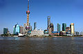
 1: Shanghai
 -
 2: Istanbul
 -

 3: Karachi
 -

 4: Delhi
 -
 5: Mumbai
 -

 6: Moscow
 -
 7: São Paulo
 -
 8: Seoul
 -
9: Beijing
-

 10: Jakarta
 -

 11:Tokyo
 -
 12:Mexico city
 -

 13:Kinshasa
 -

-
 15:Lagos
 -

 16:London
 -
 17:Lima
 -

 18:Bogota
 -
 19:Tehran
 -
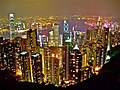 21:Hong Kong
 -

 22:Bangkok
 -

 23:Dhaka
 -
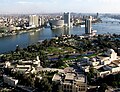
 24:Cairo
 -

 25:Hanoi
 -
 27:Lahore
 -
 28:Chongqing
 -
 29:Banglore
 -
 30:Tianjin


| Rank | City | Population | Definition | Area (km²) | Population density (/km²) | Country |
|---|---|---|---|---|---|---|
| 1 | Shanghai | 13,831,900 [7] | Core districts + inner suburbs[8] | 1,928 | 7,174 | |
| 2 | Istanbul | 13,120,596[9] | Metropolitan Municipality | 1,831 | 7,166 | |
| 3 | Karachi | 12,991,000[10] | City District | 3,527 | 3,683 | |
| 4 | Delhi | 12,565,901[11] | Municipal Corporation | 431.09[12] | 29,149 | |
| 5 | Mumbai | 12,478,447[13] | Municipal Corporation | 603 | 20,694 | |
| 6 | Moscow | 11,551,930[14] | City proper | 1,091[15] | 10,588 | |
| 7 | São Paulo | 11,244,369[16] | Municipality | 1,523 | 7,383 | |
| 8 | Seoul | 10,464,051[17] | Special City | 605.25[18] | 17,288 | |
| 9 | Beijing | 10,123,000[19] | Core districts + inner suburbs[8] | 1,368.32 | 7,400 | |
| 10 | Jakarta | 9,588,198[20] | Special capital district | 662.33 | 14,476 | |
| 11 | Tokyo | 8,887,608[21] | 23 Special Wards[22] | 617.18 | 14,400 | |
| 12 | Mexico City | 8,873,017[23] | Federal District | 1,485.49[24] | 5,973 | |
| 13 | Kinshasa | 8,754,000[25] | City-Province[26] | 2,016 | 4,342 | |
| 14 | New York City | 8,363,710[27] | City proper | 789.4 | 10,452 | |
| 15 | Lagos | 7,937,932[28] | statistical area | 999.6 | 7,938 | |
| 16 | London | 7,753,600[29] | Greater London[30] | 1,580 | 4,863 | |
| 17 | Lima | 7,605,742[31] | Province[32] | 2,670.4 | 2,848 | |
| 18 | Bogotá | 7,259,597[33] | Capital district | 1,590 | 4,566 | |
| 19 | Tehran | 7,241,000[25] | City proper | 760 | 10,359 | |
| 20 | Ho Chi Minh City | 7,162,864[34] | Province-level municipality | 2,095.01 | 3,419 | |
| 21 | Hong Kong | 7,026,400[35] | Special Administrative Region | 1,092 | 6,434 | |
| 22 | Bangkok | 7,025,000[36] | Administrative area | 1,568.74 | 4,478 | |
| 23 | Dhaka | 7,000,940[37] | City Corporation | 360[38] | 19,447 | |
| 24 | Cairo | 6,758,581[39] | Governorate | 453 | 17,190 | |
| 25 | Hanoi | 6,500,000[40] | Province-level municipality | 3,344.7 | 1,943.4 | |
| 26 | Rio de Janeiro | 6,323,037[41] | Municipality | 1,182 | 5,349 | |
| 27 | Lahore | 6,318,745[42] | City District | 1,772 | 3,566 | |
| 28 | Chongqing | 5,954,800[43] | Core districts[8] | 5,467 | 1,089 | |
| 29 | Bangalore | 5,840,155[44] | Municipal Corporation | 709.5[44] | 8,231 | |
| 30 | Tianjin | 5,800,000[45] | Core districts + inner suburbs[8] | 2,057 | 2,820 | |
| 31 | Baghdad | 5,402,486[11] | City proper | 1,134 | 4,064 | |
| 32 | Riyadh | 5,188,286[46] | City proper | 800 | 6,485 | |
| 33 | Singapore | 5,076,007[47] | Country/City | 710.2 | 7,147 | |
| 34 | Santiago | 5,012,973[48] | Province[49] | 2,030 | 2,469 | |
| 35 | Saint Petersburg | 4,868,520[14] | City proper | 1,399[15] | 3,480 | |
| 36 | Surat | 4,786,002[50] | Municipal Corporation | 326.515[51] | 14,658 | |
| 37 | Chennai | 4,616,639[11] | Municipal Corporation | 187 | 24,688 | |
| 38 | Kolkata | 4,486,679[52] | Municipal Corporation | 185 | 24,252 | |
| 39 | Yangon | 4,350,000[25] | City proper | 598.75[53] | 6,828 | |
| 40 | Guangzhou | 4,261,800[54] | Core districts[8] | 280[54] | 15,220 | |
| 41 | Alexandria | 4,110,015[39] | Governorate | 2,680 | 1,611 | |
| 42 | Shenyang | 4,101,197[55] (2006-12-31) | Core districts | 3,495 | 1,173 | |
| 43 | Hyderabad | 4,068,611[11] | Municipal Corporation | 621.48[56] | 6,546 | |
| 44 | Ahmedabad | 3,959,432[11] | Municipal Corporation | 204 | 19,944 | |
| 45 | Ankara | 3,901,201[57] | Metropolitan Municipality | 2,516 | 1,551 | |
| 46 | Johannesburg | 3,888,180[58] | Metropolitan Municipality (South Africa) | 1,644.96 | 2,364 | |
| 47 | Wuhan | 3,807,950[59] | Core districts[8] | 379.4 | 10,036 | |
| 48 | Los Angeles | 3,792,621[60] | City proper | 1,290 | 2,940 | |
| 49 | Yokohama | 3,680,267[61] | City proper | 437.38 | 8,414 | |
| 50 | Abidjan | 3,660,682[62] | Department/District | 2,119 | 1,728 | |
| 51 | Busan | 3,600,381[63] | Metropolitan City | 766.12[63] | 4,666 | |
| 52 | Cape Town | 3,497,097[58] | Metropolitan Municipality (South Africa) | 2,454.72 | 1,424 | |
| 53 | Durban | 3,468,086[58] | Metropolitan Municipality (South Africa) | 2,291.89 | 1,513 | |
| 54 | Pune | 3,446,330[11] | Municipal Corporation | 450.69 | 7,647 | |
| 55 | Jeddah | 3,430,697[46] | City proper | 1,230 | 2,789 | |
| 56 | Berlin | 3,426,354[64] | City state | 892 | 3,842 | |
| 57 | Pyongyang | 3,255,388[65] | Direct-controlled municipality | 3,194 | 1,019 | |
| 58 | Kanpur | 3,221,435[11] | Municipal Corporation | 267 | 12,065 | |
| 59 | Madrid | 3,213,271[66] | Municipality | 698 | 4,604 | |
| 60 | Jaipur | 3,210,570[11] | Municipal Corporation | 485 | 6,620 | |
| 61 | Nairobi | 3,138,369[67] | Province | 696 | 4,509 |
See also
- Lists of cities
- List of cities by surface area
- Cities of present-day nations and states
- List of capitals by population density
- List of towns and cities with 100,000 or more inhabitants
- Historical urban community sizes
- List of cities by population density
- List of largest cities throughout history
- List of metropolitan areas by population
- List of urban areas by population
- Rank mobility index
- World's largest cities (explaining alternative measure)
Notes and references
- ^ "World Urbanization Prospects: The 2007 Revision Population Database". Esa.un.org. Retrieved 2010-07-26.
- ^ "United Nations Statistics Division - Demographic and Social Statistics". Millenniumindicators.un.org. Retrieved 2010-07-26.
- ^ Demographic Yearbook 2005, Volume 57. United Nations. 2008. p. 756. ISBN 9210510992. Retrieved 2010-07-19.
- ^ World Urbanization Prospects. United Nations. 2004. p. 105. ISBN 9211413860. Retrieved 2010-07-19.
{{cite book}}: Check|isbn=value: checksum (help) - ^ For cities in China, because administrative boundaries encompass large amounts of rural territory, the urban agglomeration concept is used instead, with fully urban districts as component local government units. Chinese urban agglomerations are based on the National Bureau of Statistics definition of urban for the 2000 census. Fully urban districts are those whose population density is greater than 1,500 per km².[citation needed]
- ^ Some administrative divisions that are known as "cities" contain extensive rural territory. Only the urban parts of these administrative divisions are included in this list.[citation needed]
- ^ Shanghai Municipal Bureau of Statistics, Shanghai Statistical Yearbook 2009, Total of permanent population (including "floating population"). Retrieved on 2009-07-17. Total population as of 2008-12-31 of the following districts (core city + inner suburbs): Pudong New Area, Huangpu, Luwan, Xuhui, Changning, Jing'an, Putuo, Zhabei, Hongkou, Yangpu, Baoshan, Minhang, and Jiading.
- ^ a b c d e f Refers to fully urban districts, that is districts with a population density of over 1,500 per km².
- ^ Statistics of the 2010 Turkey census
- ^ Sindh Bureau of Statistics, Selected Tables of District Development Indicators, 2008; Population (Total) of 1998 Census and 2008 (Projected) (pdf-file)[dead link] Retrieved on 2008-08-05. Including three rural towns (Gadap Town, Bin Qasim Town, and Kiamari Town, as well as six cantonments (Clifton Cantonment, Faisal Cantonment, Karachi Cantonment, Korangi Creek Cantonment, Malir Cantonment and Manora Cantonment) under military jurisdiction.
- ^ a b c d e f g h "World: largest cities and towns and statistics of their population". World Gazetteer. Retrieved 30 March 2010.
- ^ "CHAPTER IV Area and Density – Metropolitan Cities" (PDF). Ministry of Urban Development. Government of India. Retrieved 2009-11-08.
- ^ Census of India, Provisional Population Totals and data products, Census 2011 : Maharashtra. Ranking of Districts by Population Size, 2001 and 2011 (excel) Total population of the Mumbai and Mumbai Suburban districts. Retrieved on 2011-04-09.
- ^ a b Federal State Statistics Service, Russia (xls, in Russian) 2011-01-01 Esimation based on National Census 2010-10-14. Retrieved on 2011-03-30.
- ^ a b Ministry of Economic Development of the Russian Federation. Federal Registration, Cadastre&Cartograhy Service . Russia Landuse National Report 2008, p.187-188 (in Russian)
- ^ Instituto Brasileiro de Geografia e Estatística; Censo Demografico 2010, resultados, São Paulo (zip) Retrieved on 2010-12-01. Census results for 2010-08-01.
- ^ "Seoul Statistics (Population)". Seoul Metropolitan Government. Retrieved 24 March 2010.
- ^ "Seoul Statistics (Land Area)". Seoul Metropolitan Government. Retrieved 24 March 2010.
- ^ Beijing Municipal Bureau of Statistics, Beijing Statistical Yearbook 2008, Total number of permanent population (including "floating population") Retrieved on 2009-03-14. Total population on 2007-12-31 (1% sample census) of the two functional areas of 1) Core Districts of Capital Function and 2) Urban Function Extended Districts, including eight fully urban districts. The data is for so-called 'permanent population'; registered population was 7,323,000 the same year.
- ^ Hasil Sensus Penduduk 2010, Provinsi DKI Jakarta (pdf) 2010 Census result. Retrieved on 2010-11-21.
- ^ Official monthly estimated de jure population by the Tokyo Metropolitan Government (in Japanese). Population estimate on 2010-06-01.
- ^ Corresponds to the former City of Tokyo merged into the Tokyo Metropolis on July 1, 1943. The whole of 23 wards is now a special local public entity which provides limited public service, and is sometimes statistically treated as the city proper of Tokyo (e.g. Statistical Bureau of Japan, The Population of capital cities and cities of 100 000 or more inhabitants. United Nations Statistics Division).
- ^ Instituto Nacional de Estadística y Geografía, México; Censo de Población y Vivienda 2010, Resultados preliminares Preliminary 2010 Census results. Retrieved on 2010-11-26.
- ^ Consejo Nacional de Población, México; Delimitación de las zonas metropolitanas de México 2005 Retrieved on 2010-11-26.
- ^ a b c UN world Urbanization Prospects estimate for 2010. While the UN list is nominally a list of urban agglomerations, this particular city is listed as using the "city proper" statistical concept in the sources section of the UN report.
- ^ Excluding the rural commune of Maluku
- ^ "Annual Estimates of the Resident Population for Incorporated Places Over 100,000, Ranked by July 1, 2008 Population: April 1, 2000 to July 1, 2008". US Census Bureau. Retrieved 2009-09-30.
- ^ Summing the 16 LGAs making up Metropolitan Lagos (Agege, Ajeromi-Ifelodun, Alimosho, Amuwo-Odofin, Apapa, Eti-Osa, Ifako-Ijaiye, Ikeja, Kosofe, Lagos Island, Lagos Mainland, Mushin, Ojo, Oshodi-Isolo, Shomolu, Surulere) as per:
Federal Republic of Nigeria Official Gazette (15 May 2007). "Legal Notice on Publication of the Details of the Breakdown of the National and State Provisional Totals 2006 Census" (PDF). Archived from the original (PDF) on July 4, 2007. Retrieved 2007-06-29. - ^ UK Office of National Statistics -- mid-2007 population estimate for London region
- ^ Composed of 32 London boroughs
- ^ INEI 2007 Census Results
- ^ Composed of 43 independent districts
- ^ Departamento Administrativo Nacional de Estadística. Proyecciones de población municipales por área, 2005-2009, a junio 30. (excel-file) Retrieved on 2009-08-05. Projected population on 2009-06-30.
- ^ "General Statistics Office Of Vietnam". Gso.gov.vn. Retrieved 2010-07-26.
- ^ Census and Statistics Department, Hong Kong; Population and Vital Events Retrieved on 2009-08-05. Estimated population on 2008-12-31. Including 'usual' and 'mobile' residents, but excluding temporary visitors.
- ^ National Statistical Office Thailand, Key Statistics of Thailand 2007; Chapter 1.9, Population Projections (1 July) by Region and Sex (embedded in huge 121MB zipped file!) Retrieved on 2009-08-05. Projected de facto population as of 2009. The registered (de jure) population was 5,695,956 in 2006.
- ^ Bangladesh Bureau of Statistics, Statistical Pocket Book, 2008 (pdf-file) 2008 Population Estimate. Retrieved 2009-08-05.
- ^ "Dhaka Area". Dhaka City Corporation. Retrieved 6 February 2010.
- ^ a b Central Agency for Public Mobilisation and Statistics, Population and Housing Census 2006, Governorate level, Population distribution by sex (excel-file) For Cairo, figure is an adjusted census result, as Helwan governorate was created on the 17th of April 2008 from a.o. parts of the Cairo governorate.
- ^ "General Statistics Office Of Vietnam". Gso.gov.vn. Retrieved 2010-07-26.
- ^ Instituto Brasileiro de Geografia e Estatística; Censo Demografico 2010, resultados, Rio de Janeiro (zip) Retrieved on 2010-12-01. Census results for 2010-08-01.
- ^ GeoHive, Pakistan - The Punjab - Administrative units 1998 Census result for Lahore District. Accessed on 2008-09-28. The UN estimated the population of Lahore to be 6,577,000 in 2007. However, that estimate is based on now obsolete administrative boundaries for the Lahore Metropolitan Corporation. The administrative boundaries for Lahore was changed in 2001, when it was transformed from Metropolitan Corporation into a City District. The City District includes the old Metropolitan Corporation as well as the surrounding district. The District of Lahore had a total of 6,318,745 inhabitants in 1998, compared to 5,143,495 for the Metropolitan Corporation. Current, but vague, estimates puts the population of the district at somewhere between 7.5 and 10 millions.
- ^ Chongqing Statistical Yearbook. Refers to the statistical area known as the Metropolitan Advanced Economic Sphere (都市发达经济圈) consisting of nine districts. Population figure as of 2008-12-31.
- ^ a b "BBMP Delimitation 2009". Government of Karnataka. Retrieved 2009-11-09. [dead link]
- ^ Tianjin Statistical Information Net. Retrieved on 2009-01-29. Total population as of 2005-11-01 of the following districts (core city + inner suburbs): Heping, Hedong, Hexi, Nankai, Hebei, Hongqiao, Dongli, Xiqing, Jinnan, and Beichen. Excludes the separate urban area of Binhai.
- ^ a b Central Department of Statistics and Information, Saudi Arabia; Population of cities with at least 5,000 inhabitants, at the 2010 Population Census (pdf, in arabic) Retrieved on 2010-12-13.
- ^ Statistics Singapore, Population (Mid-Year Estimates) Retrieved on September 23, 2010. Estimated population on Mid-2010, including Singapore residents plus non-residents. Population of Singapore citizens and residents was 3,642,700 on 2008-06-30.
- ^ Instituto Nacional de Estadística, Chile; Proyecciones de población al 30 de Junio 1990-2020, Region Metropolitana de Santiago; Provincias (excel-file) Retrieved on 2009-08-05. Projected population on 2009-06-30.
- ^ Composed of 32 independent municipalities
- ^ Surat Municipal Corporation; Mid-Year Population Estimates Retrieved on 2010-09-23. Projected population as of 2010 (Mid-year population estimate), including areas within the new and extended city boundaries.
- ^ Demographics: Surat Municipal Corporation
- ^ Census of India, Provisional Population Totals, Census 2011 : West Bengal. Ranking of Districts by Population Size in 2001 and 2011 (excel) Population of Kolkata District, which covers the same area as the municipal corporation. Retrieved on 2011-04-09.
- ^ Third Regional EST Forum, Presentation of Myanmar. Retrieved 6 June 2009.
- ^ a b Statistics Bureau of Guangzhou. Sum of the population of the following districts: Yuexiu, Liwan, Haizhu, and Tianhe. Population as of the end of 2008.
- ^ City and region database of Statistics Finland
- ^ "Greater Hyderabad Municipal corporation 2010". GHMC. Retrieved 12-04-2010.
{{cite web}}: Check date values in:|accessdate=(help) - ^ TUIK. "Address-based population registration system: Inside-Outside District Centers Population By Province And Sex And Population Density 2007". TUIK. Retrieved 2010-07-22.
- ^ a b c Statistics South Africa, Community Survey, 2007, Basic Results Municipalities (pdf-file) Retrieved on 2008-03-23.
- ^ Wuhan Statistical Yearbook 2009. Retrieved on 2010-04-27. Total population as of 2008-12-31 of the following districts: Jiang'an, Jianghan, Qiaokou, Hanyang, Wuchang, and Qingshan
- ^ "Population and Housing Occupancy Status: 2010 - State -- Place more information 2010 Census Redistricting Data (Public Law 94-171) Summary File (California)". U.S. Census Bureau. Retrieved 10 March 2011.
- ^ Official monthly estimated de jure population by the Kanagawa Prefectural Government (in Japanese). Population estimate on 2010-06-01.
- ^ Abidjan District estimate for 2003
- ^ a b "Busan: Population and area of Administrative units". Busan Metropolitan City. Retrieved 12 February 2011.
- ^ "Bevölkerungsstand im Land Berlin" (PDF). Amt für Statistik Berlin-Brandenburg. Retrieved 2008-07-31.
- ^ United Nations Statistics Division; Preliminary results of the 2008 Census of Population of the Democratic People’s Republic of Korea conducted on 1-15 October 2008 (pdf-file) Retrieved on 2009-03-01.
- ^ INE (2008)
- ^ Minister of State for Planning, National Development and Vision 2030; 2009 Population and Housing Census Results (pdf) Retrieved on 2010-12-13.