
Lunca de Sus: Difference between revisions
Iadrian yu (talk | contribs) m Removed the irredentism map. |
Undid revision 364279367 by Iadrian yu (talk) |
||
| Line 68: | Line 68: | ||
It lies along the [[Trotuş River]] and its tributaries as the sub-settlements, the "creeks" ({{lang-hu|patakok}}), were formed in the valleys of the tributaries. |
It lies along the [[Trotuş River]] and its tributaries as the sub-settlements, the "creeks" ({{lang-hu|patakok}}), were formed in the valleys of the tributaries. |
||
[[image:Gyimesfelsőlok map.png|right|thumb|265px|The village in the [[Székely Land]]]] |
|||
=== Stream regulation === |
=== Stream regulation === |
||
Revision as of 11:18, 26 May 2010
Lunca de Sus Gyimesfelsőlok | |
|---|---|
Commune | |
| St. Elisabeth of Hungary Church, 'The House built on the Rock' St. Elisabeth of Hungary Church, 'The House built on the Rock' | |
 Coat of arms | |
 Location of Lunca de Sus | |
| Country | |
| County | Harghita County |
| Status | Commune |
| Government | |
| • Mayor | Timár Zsombor (Democratic Union of Hungarians in Romania) |
| Area | |
| • Total | 82.6 km2 (31.9 sq mi) |
| Population (2002) | |
| • Total | 3,424 |
| Ethnicity | |
| • Hungarians | 97.13% |
| • Romanians | 2.86% |
| Time zone | UTC+2 (EET) |
| • Summer (DST) | UTC+3 (EEST) |
| Postal Code | 537155 |
| Area code | +40 266 |
| Website | http://www.gyimesfelsolok.ro |
Lunca de Sus (Hungarian: Gyimesfelsőlok; Hungarian pronunciation: [ˈɟimɛʃfɛlʃøːlok] or colloquially Felsőlok) is a commune in Harghita County, Transylvania, Romania, It is composed of 6 parts:
- Comiat / Komjátpataka
- Izvorul Trotuşului / Sántatelek (Ciherek-pataka, Bothavas-pataka, Farkas-pataka)
- Centru / Központ, including Nyíresalja and Libaváros ("Goose-city")
- Păltiniş-Ciuc / Pöltinis
- Valea Gârbea / Görbepataka
- Valea Ugra / Ugrapataka
History

The settlement came into being out of the outer areas of Szépvíz and Csíkszentmihály villages, but became a separate village only as late as around 1850.
The village is situated near the old Hungarian border, and therefore protection had to be provided. The Tartar invasions through the valley left many victims behind. In the end, in 1701-1702, the construction of a moat was commenced on Csapó-hill next to the village. The traces of the earthworks can still be seen these days at a length of 120-150 meters.
According to the tradition, the first family that settled into the valley was the Tankó-family.
The village administratively belonged to Csíkszék, then, from 1876 until 1918 to the Csík County of the Kingdom of Hungary. After WWI, by the terms of the Treaty of Trianon of 1920, it became part of Romania. As a result of the Second Vienna Award, it belonged to Hungary again between 1940 and 1944. After WWII, it came under Romanian administration and became part of Romania in 1947. Between 1952 and 1960, it formed part of the Hungarian Autonomous Province, then, of the Mureş-Hungarian Autonomous Province until it was abolished in 1968. Since then, the commune is part of Harghita County.
Demographics
The commune has an absolute Csángó Hungarian majority. In 1910, it had a population of 2288 people, of them 2170 were Hungarians and 4 were Romanians. According to the 2002 census, it has a population of 3,424 of which 97.14% or 3,326 are Hungarians. Most of the villagers are Roman Catholics.
Geography

The village is the first of the three Csángó settlements as the Gyimes-Valley (Valea Ghimeşuli) descends from its head.
It lies along the Trotuş River and its tributaries as the sub-settlements, the "creeks" (Hungarian: patakok), were formed in the valleys of the tributaries.

Stream regulation
With financial support of the European Union became completed by November 2009 the stream regulation and flood control works on Gârbea Creek. The regulation was said to be necessary as the water catchment area of the stream is large and the bed quickly filled up with rainwater with at times of rains which flooded from time to time the plots and the public road along the stream. Under the stream regulation works a 1400 meter long section of the stream has been embedded in a 2 m wide and 2.5 meter deep concrete bed. The bottom of the bed has also been covered with stones and concrete. Wide wooden bridges with yellow metal rails have been made by the brookside making easier the access by vehicle to the real estates along the river. The road has been fitted with metal railings used at motorways. [1]
Although for most of the year, only water a few inches deep trickles in the stream, experts of the Water Department of Bacău County considered that prevention of sudden floodings of the stream may only be solved by converting it into a drainage channel. According to environmentalists, life of birds, fish, frogs and other species is affected by the concrete stream-bed solution. The mayor's office and the local population, however, is satisfied with the chosen solution and consider it a sign of progress. Besides, as they say, life already died out from the stream anyway because of the waste water trickling into the stream from the neighboring cesspools.
It is envisaged by local officials that the Trotuş River and some of the mountain brooks flowing into the river will also be regulated in a similar way, if the necessary financial resources are available.[2]
-
 The unregulated stream
 -
 The regulated stream
 -
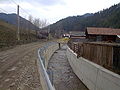
 Street view from Valea Gârbea / Görbepataka
 -
 Traditional flood protection on the Trotuş River


_River,_Gyimesfels%C5%91lok.jpg)
Education
Since 1994, the 'St. Elisabeth Catholic Grammar School' provides education not only for local students, but also for many ethnic Hungarian Csángós from Moldova. It was established by parish priest Lajos Berszán, and in the beginning the building of the Pilgrim's House named "The House built on the Rock" was used for the school's purposes.
Tourist Attractions
_St._Andrew_Parish_Church.jpg)

In 1941, a military complex consisting of barracks and officer houses was built by the Hungarian army, based on the plans of architect István Mátyás.
The buildings were built of stones and logs in the style of a mountains rest-house and provide a picturesque sight along the main road. The complex referred to as by locals as the "colony" ("kolónia") was later used as a prison, now it is used by the Romanian military.
_-_Church.jpg)
The parish of the village is named in the honor of St Andrew, the apostle. In 2009, a chapel was built in Comiat by parish priest Géza Tankó.
The village is visited every year by a great number of pilgrims who, on occasion of the Csíksomlyó Pilgrimage, set out from here on the traditional pilgrimage held since 1567 on Saturday before Whit Sunday to cover on foot the distance of approximately 35 kms to the Csíksomlyó Fransiscan Church in Şumuleu-Ciuc.
