Ponte di Tiberio (Rimini)
Ponte d'Augusto Pons Augustus Ponte di Tiberio | |
|---|---|
 | |
| Coordinates | 44°03′49″N 12°33′50″E / 44.063667°N 12.563827°E |
| Carries | Via Aemilia |
| Crosses | Marecchia (ancient Ariminus) |
| Locale | Rimini, Italy |
| Characteristics | |
| Design | Arch bridge |
| Total length | 62.6 m (between abutments) |
| Width | 8.6 m |
| Longest span | 10.6 m |
| No. of spans | 5 |
| History | |
| Construction end | 20 AD |
| Location | |
 | |
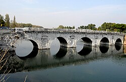
The Ponte d'Augusto (Latin: Pons Augustus) or Bridge of Tiberius (Italian: Ponte di Tiberio) is a Roman bridge in Rimini, Italy. The bridge features five semicircular arches with an average span length of ca. 8 m. Construction work started during Augustus' reign and was finished under his successor Tiberius in 20 AD; an inscription thus calls the structure as "given by both emperors".[1] The bridge was the only crossing of the Marecchia not destroyed by the retreating German army during the Battle of Rimini and is said to have resisted all attempts at destruction, including the ignition failure of explosive charges.[2] The bridge is still open to pedestrian and vehicular traffic, with the exception of heavy goods vehicles.
References
- ^ O’Connor 1993, p. 84
- ^ "Ponte di Tiberio [Tiberius Bridge]". visit-rimini.com. Retrieved 2 August 2011.
Further reading
- O’Connor, Colin (1993), Roman Bridges, Cambridge University Press, pp. 84f. (I117), ISBN 0-521-39326-4
See also
External links
![]() Media related to Ponte d'Augusto (Rimini) at Wikimedia Commons
Media related to Ponte d'Augusto (Rimini) at Wikimedia Commons
- Pons Augustus at Structurae
- Traianus – Technical investigation of Roman public works

