
Alicia, Bohol
Alicia | |
|---|---|
| Municipality of Alicia | |
 Municipality Hall | |
 Flag  Seal | |
 Map of Bohol with Alicia highlighted | |
OpenStreetMap  | |
.svg) Alicia Location within the Philippines | |
| Coordinates: 9°53′45″N 124°26′29″E / 9.895708°N 124.441517°E | |
| Country | Philippines |
| Region | Central Visayas |
| Province | Bohol |
| District | 3rd district |
| Founded | 18 January 1950 |
| Named for | Alicia Syquia |
| Barangays | 15 (see Barangays) |
| Government | |
| • Type | Sangguniang Bayan |
| • Mayor | Victoriano C. Torres III |
| • Vice Mayor | Marnilou S. Ayuban |
| • Representative | Kristine Alexie B. Tutor |
| • Municipal Council | Members |
| • Electorate | 17,111 voters (2022) |
| Area | |
| • Total | 114.50 km2 (44.21 sq mi) |
| Elevation | 84 m (276 ft) |
| Highest elevation | 400 m (1,300 ft) |
| Lowest elevation | 3 m (10 ft) |
| Population (2020 census)[3] | |
| • Total | 24,374 |
| • Density | 210/km2 (550/sq mi) |
| • Households | 5,839 |
| Economy | |
| • Income class | 4th municipal income class |
| • Poverty incidence | 27.60 |
| • Revenue | ₱ 114.7 million (2020) |
| • Assets | ₱ 329.5 million (2020) |
| • Expenditure | ₱ 126.6 million (2020) |
| • Liabilities | ₱ 66.59 million (2020) |
| Service provider | |
| • Electricity | Bohol 2 Electric Cooperative (BOHECO 2) |
| Time zone | UTC+8 (PST) |
| ZIP code | 6314 |
| PSGC | |
| IDD : area code | +63 (0)38 |
| Native languages | Boholano dialect Cebuano Tagalog |
| Patron saint | Joachim |
| Website | www |
Alicia, officially the Municipality of Alicia (Cebuano: Munisipyo sa Alicia; Tagalog: Bayan ng Alicia), is a 4th class municipality in the province of Bohol, Philippines. According to the 2020 census, it has a population of 24,374 people.[3]
Located 110 kilometres (68 mi) from Tagbilaran, it was formerly part of Mabini and was known as Batuanan (or Batuanon).[5][6]
Alicia celebrates its town fiesta on 26 July in honor of Saint Joachim.[7]
History[edit]
In the mid-19th century Alicia was one of the three largest and oldest towns of Bohol along with Catigbian and Balilihan. The town was where former followers of Dagohoy were given some land to till, but at the same time could be kept under the watchful eye of Spanish authorities.
In 1829, the year the Dagohoy Rebellion ended, the town was the largest of five such settlements, with over 6000 inhabitants.
In 1949, it became an independent municipality, which was renamed Alicia after Alicia Syquia, the wife of president Elpidio Quirino.[8] She and three of their children were massacred by the Japanese in 1945.
Geography[edit]
Barangays[edit]
Alicia is politically subdivided into 15 barangays. Each barangay consists of puroks and some have sitios.
| PSGC | Barangay | Population | ±% p.a. | |||
|---|---|---|---|---|---|---|
| 2020[3] | 2010[9] | |||||
| 071202001 | Cabatang | 3.5% | 861 | 675 | 2.46% | |
| 071202002 | Cagongcagong | 1.8% | 440 | 423 | 0.39% | |
| 071202003 | Cambaol | 5.0% | 1,216 | 1,087 | 1.13% | |
| 071202004 | Cayacay | 7.8% | 1,897 | 1,713 | 1.03% | |
| 071202005 | Del Monte | 3.4% | 834 | 806 | 0.34% | |
| 071202006 | Katipunan | 9.5% | 2,317 | 2,230 | 0.38% | |
| 071202007 | La Hacienda | 15.4% | 3,758 | 3,710 | 0.13% | |
| 071202008 | Mahayag | 2.8% | 681 | 687 | −0.09% | |
| 071202009 | Napo | 5.3% | 1,295 | 1,255 | 0.31% | |
| 071202010 | Pagahat | 3.1% | 747 | 586 | 2.46% | |
| 071202011 | Poblacion (Calingganay) | 17.3% | 4,214 | 4,064 | 0.36% | |
| 071202012 | Progreso | 4.2% | 1,031 | 1,019 | 0.12% | |
| 071202013 | Putlongcam | 7.0% | 1,698 | 1,578 | 0.74% | |
| 071202014 | Sudlon (Omhon) | 2.7% | 656 | 648 | 0.12% | |
| 071202015 | Untaga | 7.7% | 1,872 | 1,804 | 0.37% | |
| Total | 24,374 | 22,285 | 0.90% | |||
Climate[edit]
| Climate data for Alicia, Bohol | |||||||||||||
|---|---|---|---|---|---|---|---|---|---|---|---|---|---|
| Month | Jan | Feb | Mar | Apr | May | Jun | Jul | Aug | Sep | Oct | Nov | Dec | Year |
| Mean daily maximum °C (°F) | 28 (82) |
28 (82) |
29 (84) |
31 (88) |
31 (88) |
30 (86) |
30 (86) |
30 (86) |
30 (86) |
29 (84) |
29 (84) |
28 (82) |
29 (85) |
| Mean daily minimum °C (°F) | 23 (73) |
23 (73) |
23 (73) |
23 (73) |
24 (75) |
24 (75) |
24 (75) |
24 (75) |
24 (75) |
24 (75) |
24 (75) |
23 (73) |
24 (74) |
| Average precipitation mm (inches) | 98 (3.9) |
82 (3.2) |
96 (3.8) |
71 (2.8) |
104 (4.1) |
129 (5.1) |
101 (4.0) |
94 (3.7) |
99 (3.9) |
135 (5.3) |
174 (6.9) |
143 (5.6) |
1,326 (52.3) |
| Average rainy days | 18.0 | 14.1 | 17.1 | 16.8 | 23.7 | 25.7 | 25.8 | 23.3 | 24.2 | 25.9 | 24.0 | 20.6 | 259.2 |
| Source: Meteoblue[10] | |||||||||||||
Demographics[edit]
| Year | Pop. | ±% p.a. |
|---|---|---|
| 1960 | 11,860 | — |
| 1970 | 12,717 | +0.70% |
| 1975 | 14,770 | +3.05% |
| 1980 | 15,766 | +1.31% |
| 1990 | 18,653 | +1.70% |
| 1995 | 19,402 | +0.74% |
| 2000 | 21,605 | +2.33% |
| 2007 | 23,422 | +1.12% |
| 2010 | 22,285 | −1.79% |
| 2015 | 23,517 | +1.03% |
| 2020 | 24,374 | +0.71% |
| Source: Philippine Statistics Authority[11][9][12][13] | ||
Economy[edit]
Graphs are unavailable due to technical issues. There is more info on Phabricator and on MediaWiki.org. |
Education[edit]
- Katipunan Elementary School, in Katipunan, Alicia, Bohol, Philippines. The Alicia Bamboo Ensemble or the Alicia's Musika Kawayan therein is a school-based orchestra, which has received the National Champion Prize (1994, 1996, and 2000) in the National Musical Competition for Young Artists (NAMCYA).
Government[edit]
List of former chief executives[edit]
List of former mayors of Alicia:[5]
- Pedro Huiso1950–1955
- Exequiel Madriñan
- Leoncio Garcia1956–1959
- Jesus Madriñan1960–1980
- Dominador Molina1980–1987
- Exequiel Madriñan Jr1988–1995
- Basilio Balahay1995–2001
- Bienvenido Molina2001–2007
- Pedro Miasco2007–2010
- Marnilou Ayuban2010–
Gallery[edit]
-
 Poblacion and public market
 -
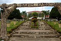 Plaza and town hall
 -
 Residential street in Alicia
 -
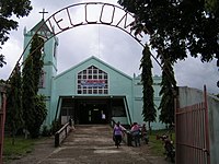 Church


Notable People[edit]
Maryo J. de los Reyes[citation needed], filmmaker
References[edit]
- ^ Municipality of Alicia | (DILG)
- ^ "2015 Census of Population, Report No. 3 – Population, Land Area, and Population Density" (PDF). Philippine Statistics Authority. Quezon City, Philippines. August 2016. ISSN 0117-1453. Archived (PDF) from the original on May 25, 2021. Retrieved July 16, 2021.
- ^ a b c Census of Population (2020). "Region VII (Central Visayas)". Total Population by Province, City, Municipality and Barangay. Philippine Statistics Authority. Retrieved 8 July 2021.
- ^ "PSA Releases the 2018 Municipal and City Level Poverty Estimates". Philippine Statistics Authority. 15 December 2021. Retrieved 22 January 2022.
- ^ a b "Historical Sketch of the Municipality of Alicia". Municipality of Alicia. Archived from the original on 2013-07-17. Retrieved 2012-09-07.
- ^ Tirol, Jes. Establishment of Batuanan town, its abolition and re-establishment as Alicia town Archived 2007-09-28 at the Wayback Machine
- ^ "Bohol Fiesta Schedule". boholic.com. Retrieved February 12, 2019.
- ^ "History of Alicia". www.bohol-philippines.com. Retrieved 2019-04-10.
- ^ a b Census of Population and Housing (2010). "Region VII (Central Visayas)" (PDF). Total Population by Province, City, Municipality and Barangay. National Statistics Office. Retrieved 29 June 2016.
- ^ "Alicia: Average Temperatures and Rainfall". Meteoblue. Retrieved 9 May 2020.
- ^ Census of Population (2015). "Region VII (Central Visayas)". Total Population by Province, City, Municipality and Barangay. Philippine Statistics Authority. Retrieved 20 June 2016.
- ^ Censuses of Population (1903–2007). "Region VII (Central Visayas)". Table 1. Population Enumerated in Various Censuses by Province/Highly Urbanized City: 1903 to 2007. National Statistics Office.
{{cite encyclopedia}}: CS1 maint: numeric names: authors list (link) - ^ "Province of Bohol". Municipality Population Data. Local Water Utilities Administration Research Division. Retrieved 17 December 2016.
- ^ "Poverty incidence (PI):". Philippine Statistics Authority. Retrieved December 28, 2020.
- ^ "Estimation of Local Poverty in the Philippines" (PDF). Philippine Statistics Authority. 29 November 2005.
- ^ "2003 City and Municipal Level Poverty Estimates" (PDF). Philippine Statistics Authority. 23 March 2009.
- ^ "City and Municipal Level Poverty Estimates; 2006 and 2009" (PDF). Philippine Statistics Authority. 3 August 2012.
- ^ "2012 Municipal and City Level Poverty Estimates" (PDF). Philippine Statistics Authority. 31 May 2016.
- ^ "Municipal and City Level Small Area Poverty Estimates; 2009, 2012 and 2015". Philippine Statistics Authority. 10 July 2019.
- ^ "PSA Releases the 2018 Municipal and City Level Poverty Estimates". Philippine Statistics Authority. 15 December 2021. Retrieved 22 January 2022.