
File:Browns Valley flood 07.jpg

Size of this preview: 800 × 600 pixels. Other resolutions: 320 × 240 pixels | 640 × 480 pixels | 1,024 × 768 pixels | 1,280 × 960 pixels | 2,400 × 1,800 pixels.
Original file (2,400 × 1,800 pixels, file size: 609 KB, MIME type: image/jpeg)
| This is a file from the Wikimedia Commons. Information from its description page there is shown below. Commons is a freely licensed media file repository. You can help. |
Summary
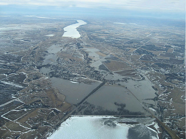
| Description | Aerial photograph showing the Traverse Gap in Minnesota and South Dakota and flooding at Browns Valley, Minnesota, from ice-covered Lake Traverse (bottom of frame), south to Big Stone Lake (top of image). Interbasin flooding is shown: The Little Minnesota River, which originates in the Mississippi watershed, enters the Traverse Gap from the west (right) and flows south to Big Stone Lake, is flooding the gap and Browns Valley (center); at the lower right floodwaters are crossing the continental divide into Lake Traverse in the watershed of Hudson Bay. |
| Date | |
| Source | JOR Engineering, Inc. |
| Author | JOR Engineering, Inc. |
| Permission (Reusing this file) |
"I agree to publish/allow publication of that work under the free license known as the 'GNU Free Documentation License'" . . . |
Licensing

|
Permission is granted to copy, distribute and/or modify this document under the terms of the GNU Free Documentation License, Version 1.2 or any later version published by the Free Software Foundation; with no Invariant Sections, no Front-Cover Texts, and no Back-Cover Texts. A copy of the license is included in the section entitled GNU Free Documentation License. |
| This file is licensed under the Creative Commons Attribution-Share Alike 3.0 Unported license. | ||
| ||
| This licensing tag was added to this file as part of the GFDL licensing update. |
File history
Click on a date/time to view the file as it appeared at that time.
| Date/Time | Thumbnail | Dimensions | User | Comment | |
|---|---|---|---|---|---|
| current | 07:06, 21 September 2010 | | 2,400 × 1,800 (609 KB) | Sreejithk2000 | Removed watermark |
| 20:17, 10 May 2007 |  | 2,400 × 1,800 (404 KB) | Kablammo | {{Information |Description=Aerial photograph showing the Traverse Gap in Minnesota and South Dakota and flooding at Browns Valley, Minnesota, from Lake Traverse (bottom of frame) south to Big Stone Lake (top of image.) Interbasin flooding is shown: The L |
File usage
The following pages on the English Wikipedia use this file (pages on other projects are not listed):
Global file usage
The following other wikis use this file:
- Usage on arz.wikipedia.org
- Usage on da.wikipedia.org
- Usage on de.wikipedia.org
- Usage on es.wikipedia.org
- Usage on fr.wikipedia.org
- Usage on pt.wikipedia.org
- Usage on sv.wikipedia.org
- Usage on www.wikidata.org