
File:Somalian Piracy Threat Map 2010.png

Size of this preview: 800 × 566 pixels. Other resolutions: 320 × 226 pixels | 640 × 452 pixels | 1,024 × 724 pixels | 1,280 × 905 pixels | 2,560 × 1,810 pixels | 3,389 × 2,396 pixels.
Original file (3,389 × 2,396 pixels, file size: 2 MB, MIME type: image/png)
| This is a file from the Wikimedia Commons. Information from its description page there is shown below. Commons is a freely licensed media file repository. You can help. |

|
File:Somalian Piracy Threat 2010 map-fr.svg is a vector version of this file. It should be used in place of this PNG file when not inferior.
File:Somalian Piracy Threat Map 2010.png → File:Somalian Piracy Threat 2010 map-fr.svg
For more information, see Help:SVG. |
 |
Summary
| Description |
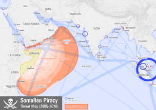
English: Map showing the extent of Somali pirate attacks on shipping vessels between 2005 and 2010.
Français : Carte montrant l'étendue des attaques de pirates somaliens sur des navires de transport entre 2005 et 2010. |
| Date | |
| Source |
Own work
|
| Author | Planemad |

|
Attribution information, such as the author's name, e-mail, website, or signature, that was once visible in the image itself has been moved into the image metadata and/or image description page. This makes the image easier to reuse and more language-neutral, and makes the text easier to process and search for. Commons discourages placing visible author information in images.
|
Licensing
| NATIONAL INSTITUTE OF DESIGN Bangalore Campus This is a work of a student or faculty from the National Institute of Design (India), 2024 |
CC-by-sa Arun Ganesh, National Institute of Design Bangalore
|
This file is licensed under the Creative Commons Attribution-Share Alike 3.0 Unported license.
- You are free:
- to share – to copy, distribute and transmit the work
- to remix – to adapt the work
- Under the following conditions:
- attribution – You must give appropriate credit, provide a link to the license, and indicate if changes were made. You may do so in any reasonable manner, but not in any way that suggests the licensor endorses you or your use.
- share alike – If you remix, transform, or build upon the material, you must distribute your contributions under the same or compatible license as the original.
File history
Click on a date/time to view the file as it appeared at that time.
| Date/Time | Thumbnail | Dimensions | User | Comment | |
|---|---|---|---|---|---|
| current | 21:00, 12 February 2012 | | 3,389 × 2,396 (2 MB) | Quibik | Removed the data surce information too: this belongs in the image description. |
| 20:18, 12 February 2012 |  | 3,389 × 2,396 (2.04 MB) | Jbarta | remove unnecessary text | |
| 12:11, 21 January 2011 |  | 3,389 × 2,396 (2.01 MB) | Planemad | port legibility | |
| 12:08, 21 January 2011 |  | 1,716 × 2,426 (811 KB) | Planemad | port legibility | |
| 12:04, 21 January 2011 |  | 3,389 × 2,396 (2.01 MB) | Planemad | port legibility | |
| 12:00, 21 January 2011 |  | 3,389 × 2,396 (1.99 MB) | Planemad | update with asam locations and ethiopia typo | |
| 17:10, 31 December 2010 |  | 3,389 × 2,396 (1.98 MB) | Planemad | {{Information |Description={{en|1=test}} |Source={{own}} |Author=Planemad |Date=2010-12-31 |Permission= |other_versions= }} |
File usage
The following pages on the English Wikipedia use this file (pages on other projects are not listed):
- Anti-piracy measures in Somalia
- Carré d'As IV incident
- List of conflicts in Somalia
- Maritime history
- Naval Special Warfare Command (Thailand)
- Operation Umeed-e-Nuh
- Piracy
- Piracy in the 21st century
- String of Pearls (Indian Ocean)
- Talk:Piracy off the coast of Somalia
- User:Joelton Ivson/Gather lists/24614 – Somália
- User:Joelton Ivson/Gather lists/24888 – Piratas
- Wikipedia:Graphics Lab/Photography workshop/Eight Requests/Archive/2012
- Portal:Piracy
Global file usage
The following other wikis use this file:
- Usage on af.wikipedia.org
- Usage on ar.wikipedia.org
- Usage on bn.wikipedia.org
- Usage on ca.wikipedia.org
- Usage on cs.wikipedia.org
- Usage on de.wikipedia.org
- Usage on es.wikipedia.org
- Usage on et.wikipedia.org
- Usage on fa.wikipedia.org
- Usage on fi.wikipedia.org
- Usage on fr.wikipedia.org
- Usage on fy.wikipedia.org
- Usage on gl.wikipedia.org
- Usage on he.wikipedia.org
- Usage on he.wikivoyage.org
- Usage on hu.wikipedia.org
- Usage on id.wikipedia.org
- Usage on it.wikipedia.org
- Usage on ja.wikipedia.org
- Usage on ko.wikipedia.org
- Usage on lt.wikipedia.org
- Usage on no.wikipedia.org
- Usage on pl.wikipedia.org
- Usage on pt.wikipedia.org
- Usage on ro.wikipedia.org
- Usage on ru.wikipedia.org
- Usage on so.wikipedia.org
- Usage on sr.wikipedia.org
- Usage on th.wikipedia.org
- Usage on tr.wikipedia.org
- Usage on ur.wikipedia.org
- Usage on www.wikidata.org
- Usage on zh.wikipedia.org