
Jagna
Jagna | |
|---|---|
| Municipality of Jagna | |
 Jagna Town Hall | |
 Flag  Seal | |
 Map of Bohol with Jagna highlighted | |
OpenStreetMap  | |
.svg) Jagna Location within the Philippines | |
| Coordinates: 9°39′N 124°22′E / 9.65°N 124.37°E | |
| Country | Philippines |
| Region | Central Visayas |
| Province | Bohol |
| District | 3rd district |
| Founded | 29 September 1631 |
| Barangays | 33 (see Barangays) |
| Government | |
| • Type | Sangguniang Bayan |
| • Mayor | Joseph A. Rañola |
| • Vice Mayor | Teofisto P. Pagar Jr. |
| • Representative | Kristine Alexie B. Tutor |
| • Municipal Council | Members |
| • Electorate | 21,499 voters (2022) |
| Area | |
| • Total | 168.49 km2 (65.05 sq mi) |
| Elevation | 106 m (348 ft) |
| Highest elevation | 641 m (2,103 ft) |
| Lowest elevation | 0 m (0 ft) |
| Population (2020 census)[3] | |
| • Total | 35,832 |
| • Density | 210/km2 (550/sq mi) |
| • Households | 8,381 |
| Economy | |
| • Income class | 3rd municipal income class |
| • Poverty incidence | 17.90 |
| • Revenue | ₱ 160.9 million (2020) |
| • Assets | ₱ 307.3 million (2020) |
| • Expenditure | ₱ 146.8 million (2020) |
| • Liabilities | ₱ 82.64 million (2020) |
| Service provider | |
| • Electricity | Bohol 2 Electric Cooperative (BOHECO 2) |
| Time zone | UTC+8 (PST) |
| ZIP code | 6308 |
| PSGC | |
| IDD : area code | +63 (0)38 |
| Native languages | Boholano dialect Cebuano Tagalog |
Jagna, officially the Municipality of Jagna (Cebuano: Munisipalidad sa Jagna; Tagalog: Bayan ng Jagna), is a 3rd class municipality in the province of Bohol, Philippines. According to the 2020 census, it has a population of 35,832 people.[3]
The town celebrates St. Michael's festival on September 29.[5] Highlights are cultural activities such as parades and street dancing. The month of May is also of interest, especially to returning Jagna-born Filipinos from across the islands and abroad. Celebrations of barangay fiestas occur almost every day.
History[edit]
On January 24, 1744, an Italian Jesuit curate in-charge of the town parish was killed by a native insurgent known to be Francisco Dagohoy. This event signaled the beginning of the Dagohoy Rebellion – the longest uprising in Philippine history.
The Lonoy Massacre in 1901 was a bloody American surprise attack launched on Filipino insurgents – the latter being led by Captain Gregorio Caseñas[a] – which were killed over 400, in the Philippine–American War. It was fought in the mountain village of Lonoy, north of the town proper.
A major earthquake devastated the town in 1990. The local residents were evacuated to the nearby hills for a few days, as local authorities warned of a possible tsunami that might hit the coastal area. However, such event did not happen. Some damage occurred to the church bell tower by the earthquake but has been completely repaired.
Jagna has a new market; the last one burned down in 1998 and a temporary market was set up in the grass field across the church. The new market is in operation – built on the site of the previous one that burned down. A recreational plaza is recently in construction on the grass field that was once the temporary market area.
Geography[edit]
Jagna is located on the southern coast of Bohol. It is one of the commercial trading centers of the province with daily market and port operations. Of interest to visitors is the town church built during the Spanish era, with its ceiling frescoes and baroque architecture. A waterfall and a spring reservoir can be found on the highlands, accessible by road travel north. A marine sanctuary zone has been set up by the local government just off the shore. A double reef is protected inside the sanctuary zone and marked off by buoys to restrict access from fishers.
Like Tagbilaran, Jagna is a port town. Ferries travel daily to and from other islands. Routes to Mindanao are available via Cagayan de Oro and Butuan. The island of Camiguin is visible from Jagna and a ferry operates from Jagna to the port of Balbagon in peak seasons. Jagna is 68 kilometres (42 mi) from Tagbilaran.
Barangays[edit]

Jagna is politically subdivided into 33 barangays. Each barangay consists of puroks and some have sitios.
| PSGC | Barangay | Population | ±% p.a. | |||
|---|---|---|---|---|---|---|
| 2020[3] | 2010[6] | |||||
| 071225001 | Alejawan | 2.3% | 817 | 843 | −0.31% | |
| 071225002 | Balili | 3.4% | 1,233 | 1,263 | −0.24% | |
| 071225003 | Boctol | 3.1% | 1,103 | 1,023 | 0.76% | |
| 071225005 | Bunga Ilaya | 2.8% | 994 | 816 | 1.99% | |
| 071225006 | Bunga Mar | 4.1% | 1,459 | 1,385 | 0.52% | |
| 071225004 | Buyog | 1.0% | 344 | 386 | −1.15% | |
| 071225007 | Cabunga‑an | 3.8% | 1,344 | 1,179 | 1.32% | |
| 071225008 | Calabacita | 4.0% | 1,419 | 1,362 | 0.41% | |
| 071225009 | Cambugason | 3.0% | 1,071 | 993 | 0.76% | |
| 071225010 | Can‑ipol | 1.4% | 505 | 511 | −0.12% | |
| 071225014 | Can‑uba | 1.1% | 378 | 343 | 0.98% | |
| 071225015 | Can‑upao | 5.8% | 2,067 | 2,037 | 0.15% | |
| 071225011 | Canjulao | 8.0% | 2,870 | 2,752 | 0.42% | |
| 071225012 | Cantagay | 2.6% | 915 | 834 | 0.93% | |
| 071225013 | Cantuyoc | 2.3% | 830 | 884 | −0.63% | |
| 071225016 | Faraon | 1.6% | 581 | 547 | 0.60% | |
| 071225017 | Ipil | 0.9% | 321 | 319 | 0.06% | |
| 071225018 | Kinagbaan | 1.3% | 466 | 436 | 0.67% | |
| 071225019 | Laca | 0.7% | 257 | 316 | −2.05% | |
| 071225020 | Larapan | 2.2% | 778 | 764 | 0.18% | |
| 071225021 | Lonoy | 3.6% | 1,286 | 1,259 | 0.21% | |
| 071225022 | Looc | 2.1% | 740 | 865 | −1.55% | |
| 071225023 | Malbog | 3.0% | 1,078 | 1,031 | 0.45% | |
| 071225024 | Mayana | 6.2% | 2,235 | 1,482 | 4.19% | |
| 071225025 | Naatang | 1.6% | 583 | 580 | 0.05% | |
| 071225026 | Nausok | 1.0% | 349 | 348 | 0.03% | |
| 071225027 | Odiong | 2.7% | 979 | 1,023 | −0.44% | |
| 071225028 | Pagina | 3.6% | 1,297 | 1,405 | −0.80% | |
| 071225029 | Pangdan | 3.3% | 1,177 | 1,197 | −0.17% | |
| 071225030 | Poblacion (Pondol) | 2.5% | 885 | 1,020 | −1.41% | |
| 071225031 | Tejero | 4.0% | 1,440 | 1,412 | 0.20% | |
| 071225032 | Tubod Mar | 1.5% | 538 | 516 | 0.42% | |
| 071225033 | Tubod Monte | 4.3% | 1,553 | 1,435 | 0.79% | |
| Total | 35,832 | 32,566 | 0.96% | |||
Climate[edit]
| Climate data for Jagna, Bohol | |||||||||||||
|---|---|---|---|---|---|---|---|---|---|---|---|---|---|
| Month | Jan | Feb | Mar | Apr | May | Jun | Jul | Aug | Sep | Oct | Nov | Dec | Year |
| Mean daily maximum °C (°F) | 28 (82) |
29 (84) |
30 (86) |
31 (88) |
31 (88) |
30 (86) |
30 (86) |
30 (86) |
30 (86) |
29 (84) |
29 (84) |
29 (84) |
30 (85) |
| Mean daily minimum °C (°F) | 23 (73) |
22 (72) |
23 (73) |
23 (73) |
24 (75) |
25 (77) |
24 (75) |
24 (75) |
24 (75) |
24 (75) |
23 (73) |
23 (73) |
24 (74) |
| Average precipitation mm (inches) | 102 (4.0) |
85 (3.3) |
91 (3.6) |
75 (3.0) |
110 (4.3) |
141 (5.6) |
121 (4.8) |
107 (4.2) |
111 (4.4) |
144 (5.7) |
169 (6.7) |
139 (5.5) |
1,395 (55.1) |
| Average rainy days | 18.6 | 14.8 | 16.5 | 16.7 | 23.9 | 26.4 | 25.6 | 24.1 | 24.4 | 26.3 | 23.7 | 20.5 | 261.5 |
| Source: Meteoblue[7] | |||||||||||||
Government[edit]
The municipality is governed by the Local Government Unit (LGU) of Jagna, which is headed by the Municipal Mayor.[8]
| Year | Municipal Mayor |
|---|---|
| 2019–present | Joseph A. Rañola |
| 2010–2019 | Atty. Fortunato A. Abrenilla |
| 2001-2010 | Exuperio C. Lloren |
| 1995-2001 | Marciana O. Tsurumi |
| 1988-1995 | Atty. Alexander C. Villacastin |
| 1986-1988 | Cesar M. Cagulada |
| 1980-1986 | Atty. Alexander C. Villacastin |
| 1972-1980 | Atty. H. Domingo Bagaipo |
| 1968-1971 | Atty. Alexander C. VIllacastin |
| Nov. 1967 - Dec. 1967 | Glicerio Madrazo |
| 1965 - Aug. 1967 | Agripino Jamisola |
| 1955-1965 | Teodoro B. Galagar |
| 1946-1955 | Antonio Galope |
| 1941-1946 | Ubaldo Yap |
| 1931-1940 | Simplicio Cagampang |
| 1922-1931 | Juan Virtudes |
| 1916-1922 | Agustin Abrenilla |
| 1912-1916 | Catalino Caseñas |
| 1906-1912 | Agustin Abrenilla |
| 1902-1906 | Quintin Abrenilla |
| 1886-1898 | Severo Salas |
| 1882-1884 | Cruz Abrenilla |
Demographics[edit]
| Year | Pop. | ±% p.a. |
|---|---|---|
| 1903 | 4,331 | — |
| 1918 | 6,643 | +2.89% |
| 1939 | 12,384 | +3.01% |
| 1948 | 15,804 | +2.75% |
| 1960 | 12,177 | −2.15% |
| 1970 | 14,338 | +1.65% |
| 1975 | 15,903 | +2.10% |
| 1980 | 16,769 | +1.07% |
| 1990 | 21,135 | +2.34% |
| 1995 | 23,927 | +2.35% |
| 2000 | 26,826 | +2.48% |
| 2007 | 27,852 | +0.52% |
| 2010 | 32,566 | +5.86% |
| 2015 | 33,892 | +0.76% |
| 2020 | 35,832 | +1.10% |
| Source: Philippine Statistics Authority[9][6][10][11] | ||
Economy[edit]
Graphs are unavailable due to technical issues. There is more info on Phabricator and on MediaWiki.org. |
Education[edit]
Jagna as a key center for learning, the municipality boasts a cluster of respected educational institutions. It hosts many notable educational institutions in the southern part of Bohol including:
- Bohol Institute of Technology
- Calabacita National High School
- Central Visayan Institute Foundation
- Colegio de la Medalla Milagrosa
- Faraon National High School
- Jagna High School
- Lonoy Heroes Memorial High School
- San Miguel Academy
- Tubod Monte Integrated School
Gallery[edit]
-
 Pagina, Jagna
 -
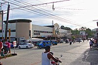 Public market of Jagna
 -
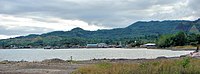 Jagna Bay
 -
 St. Michael the Archangel Parish, Jagna


Notes[edit]
- ^ who now features at the centre of the municipal seal
References[edit]
- ^ Municipality of Jagna | (DILG)
- ^ "2015 Census of Population, Report No. 3 – Population, Land Area, and Population Density" (PDF). Philippine Statistics Authority. Quezon City, Philippines. August 2016. ISSN 0117-1453. Archived (PDF) from the original on May 25, 2021. Retrieved July 16, 2021.
- ^ a b c Census of Population (2020). "Region VII (Central Visayas)". Total Population by Province, City, Municipality and Barangay. Philippine Statistics Authority. Retrieved 8 July 2021.
- ^ "PSA Releases the 2018 Municipal and City Level Poverty Estimates". Philippine Statistics Authority. 15 December 2021. Retrieved 22 January 2022.
- ^ "Jagna Feast Dayof St. Michael the Archangel". www.bohol-philippines.com. Retrieved February 14, 2019.
- ^ a b Census of Population and Housing (2010). "Region VII (Central Visayas)" (PDF). Total Population by Province, City, Municipality and Barangay. National Statistics Office. Retrieved 29 June 2016.
- ^ "Jagna: Average Temperatures and Rainfall". Meteoblue. Retrieved 9 May 2020.
- ^ About Jagna
- ^ Census of Population (2015). "Region VII (Central Visayas)". Total Population by Province, City, Municipality and Barangay. Philippine Statistics Authority. Retrieved 20 June 2016.
- ^ Censuses of Population (1903–2007). "Region VII (Central Visayas)". Table 1. Population Enumerated in Various Censuses by Province/Highly Urbanized City: 1903 to 2007. National Statistics Office.
{{cite encyclopedia}}: CS1 maint: numeric names: authors list (link) - ^ "Province of Bohol". Municipality Population Data. Local Water Utilities Administration Research Division. Retrieved 17 December 2016.
- ^ "Poverty incidence (PI):". Philippine Statistics Authority. Retrieved December 28, 2020.
- ^ "Estimation of Local Poverty in the Philippines" (PDF). Philippine Statistics Authority. 29 November 2005.
- ^ "2003 City and Municipal Level Poverty Estimates" (PDF). Philippine Statistics Authority. 23 March 2009.
- ^ "City and Municipal Level Poverty Estimates; 2006 and 2009" (PDF). Philippine Statistics Authority. 3 August 2012.
- ^ "2012 Municipal and City Level Poverty Estimates" (PDF). Philippine Statistics Authority. 31 May 2016.
- ^ "Municipal and City Level Small Area Poverty Estimates; 2009, 2012 and 2015". Philippine Statistics Authority. 10 July 2019.
- ^ "PSA Releases the 2018 Municipal and City Level Poverty Estimates". Philippine Statistics Authority. 15 December 2021. Retrieved 22 January 2022.
External links[edit]
- Bohol
- Philippine Standard Geographic Code
- Municipality of Jagna
- Jagna Bohol
- Latest Jagna News Tubag Bohol
- Jagna
Places adjacent to Jagna | |
|---|---|
| International | |
|---|---|
| National | |